Waldachtal in the Black Forest

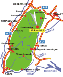
Map: Waldachtal in the Black Forest
Information in brief
- Location: in the Northern Black Forest, 10 km east of Freudenstadt
- A 81 exit at Horb a.N. (No. 30)
- 550-700 m above sea level
- 5.800 inhabitants
- Districts: Cresbach, Oberwaldach, Unterwaldach, Vesperweiler, Hörschweiler, Lützenhardt, Salzstetten, Tumlingen
Description
The municipality of Waldachtal came into being as part of the local government reform in 1974 through the merger of the communities of Cresbach, Hörschweiler, Lützenhardt, Salzstetten and Tumlingen, which were independent up until then. The stimulating mild climate in the gentle valley of the Waldach is suitable for relaxation, holiday and a health cure all the year round. 140 km of well sign-posted and mostly flat hiking trails open up the shady coniferous forests, and also provide the opportunity for Nordic walking or cycle tours.


