


Black Forest Map
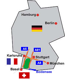
Map: Location of the Black Forest in Germany
Information in brief
- The Black Forest lies in Baden-Württemberg in the southwest of Germany
- Length approx. 160 km, width approx. 40 - 60 km
Description
Roughly speaking, the Black Forest forms an elongated rectangle between Karlsruhe, Stuttgart, Basle and Lake Constance. The Black Forest borders on France in the west and Switzerland in the south. The towns and villages and tourist attractions in the Black Forest can be quickly reached by car via the two autobahns running east and west of the Black Forest, the A5 (Rhine Valley Autobahn, Karlsruhe - Basle) and A81 (Lake Constance Autobahn, Stuttgart - Singen).
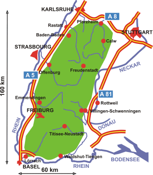
Map: Black Forest
The main railway lines run almost in parallel to these autobahns. There are some railway lines which cross the Black Forest, e.g. the Murg Valley Railway, Kinzig Valley Railway, Black Forest Railway and the Höllental Railway, as well as several branch lines.
Geographic data
The Black Forest has a length of approx. 160 km in a north-south direction and a width of approx. 60 km in the south and somewhat less in the north.
Karlsruhe is on the 49th parallel, Freiburg on the 48th and Basle at approx. 47° 30' N. The east/west limits of the Black Forest are between approx. 7° 40' and 8° 45' E.