

Wieden in the Black Forest
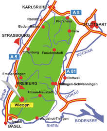
Map: Wieden in the Black Forest
Information in brief
- Location: südlicher Black Forest, 20 km south of Freiburg
- Autobahn A 5 exit at Bad Krozingen (No. 64a)
- 850-1300 m above sea level
- 600 inhabitants
- Districts: Ungendwieden, Rütte, Steinbühl, Hüttbach, Oberwieden, Warbach, Laitenbach, Säge, Graben
Description
Wieden in the Southern Black Forest is situated in the upper Wiese valley, between the mountains Feldberg and Belchen.
Further information
Further information - links

Photo: The Wiedenbach valley

Photo: View on Wieden