


Rheinfelden (Baden)
Map: Black Forest
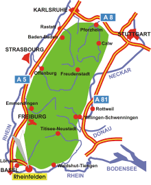
Information in brief
- Location: at the south edge of the Black Forest, 20 km east of Basel
- Autobahn A 98 triangle Rheinfelden (No. 7)
- 280 m above sea level
- 32.000 inhabitants
- Districts: Adelhausen, Degerfelden, Eichsel, Herten, Karsau, Minseln, Nollingen, Nordschwaben, Warmbach
Description
Rheinfelden (Baden) is situated on the southernmost edge of Germany, near the Swiss border.