


Ehrenkirchen in the Black Forest
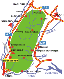
Map: Ehrenkirchen in the Black Forest
Information in brief
- Location: in the Southern Black Forest, 15 km south of Freiburg
- A 5 exit at Bad Krozingen (No. 64a)
- 215-916 m above sea level
- 7.200 inhabitants
- Districts: Ehrenstetten, Kirchhofen, Norsingen, Offnadingen, Scherzingen
Description
The Municipality of Ehrenkirchen reaches from the Black Forest foothills to the Schauinsland summit on 1284 m above sea level.