


Löffingen in the Black Forest
Map: Black Forest
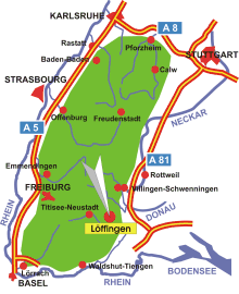
Information in brief
- Location: at the eastern edge of the Black Forest, 30 km south of Villingen-Schwenningen
- Autobahn A 81 exit at Geisingen (No. 38) or Dreieck Bad Dürrheim (No. 37)
- 800-935 m above sea level
- 7.600 inhabitants
- Districts: Bachheim, Dittishausen, Göschweiler, Reiselfingen, Seppenhofen , Unadingen
Description
Löffingen is situated at the eastern edge of the Black Forest, 30 km south of Villingen-Schwenningen.